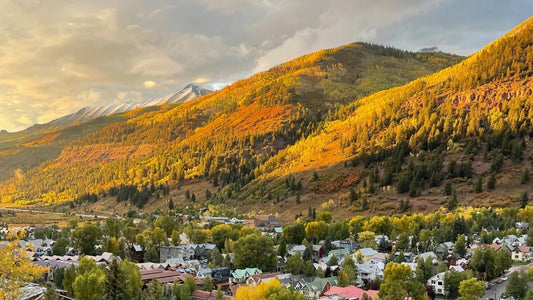
Cover Photo Provided By: Madeleine Balestrier
The summer in Telluride, Colorado is traversing the via ferrata at sunset, biking singletrack, hiking through fields of wildflowers, and swimming in high alpine lakes. It’s one of the best times of the year in this little mountain town. Few places offer idyllic views and front-door high alpine access, like Telluride.
During the summer, the best time to visit Telluride is from July through September when the snow has melted, the wildflowers are putting on a show, the mushrooms are rampant, and festivals are in full swing. Stick around for fall to experience the leaves turning and a golden encore.
Here are the best hikes in Telluride:
Easy Hikes in Telluride
Telluride River Trail
 Photo Credit: Madeleine Balestrier
Distance: 6.6 miles (10.6 kilometers)
Elevation Gain: 393 feet (120 meters)
Duration: 2 hours
Difficulty: Easy
Type: Out & Back
Location: 37.935203, -107.812720
If it’s your first time in Telluride, the River Trail is an ideal first hike or stroll at any time of the year. The mellow trail follows the San Miguel River from the Pandora Mill near the Bridal Veil Falls trailhead to the Conoco Gas Station just outside of town to the west. It’s easily personalized for how long you want to run, hike, bike, or even paddle board in the river with easy access to get on and off.
Local’s Tip: Grab a cuppa from Coffee Cowboy and take a morning stroll along Telluride’s River Trail towards the east end for the best views.
Bridal Veil Falls
Distance: 2.0 miles (3.2 kilometers)
Elevation Gain: 826 feet (252 meters)
Duration: 1-2 hours
Difficulty: Easy
Type: Out & Back
Location: 37.928726, -107.776908
Bridal Veil Falls is a quintessential hike in Telluride. It’s an out-and-back that leads you to the tallest free-falling waterfall in Colorado. The waterfall towers over the Box Canyon at 365 feet. Although a quick trail, this zone is also the starting point for the via ferrata and other longer hikes in the area, like Ajax and Blue Lake.
Moderate Hikes in Telluride
Bear Creek
 Photo Provided By: Madeleine Balestrier
Distance: 4.5 miles (7.2 kilometers)
Elevation Gain: 1,092 feet (333 meters)
Duration: 2 hours
Difficulty: Moderate
Type: Out & Back
Location: 37.9343, -107.8119
Bear Creek is a popular hike in Telluride because of its access from town, gradual incline, and, of course, the views. The trail pushes further and further into the canyon on the south side of town until hikers are rewarded with gushing waterfalls. If the River Trail is your first experience hiking in Telluride, then Bear Creek should be next up on your list.
Blue Lake via Bridal Veil Falls
Distance: 7.7 miles (12.4 kilometers)
Elevation Gain: 2,669 feet (814 meters)
Duration: 4-6 hours
Difficulty: Moderate
Type: Out & Back
Location: 37.928726, -107.776908
There is no shortage of high alpine lakes in the San Juans, including Blue Lake (not to be confused with Blue Lakes) that resides above Telluride in Bridal Veil Basin like the town’s crown. Although it’s a longer hike, Blue Lake via the Bridal Veil Falls trailhead is doable once acclimated.
Cross Mountain Trail
Distance: 7.2 miles (11.6 kilometers)
Elevation Gain: 2,122 feet (646.8 meters)
Duration: 4-5 hours
Difficulty: Moderate
Type: Out & Back
Location: 37.79642, -107.93589
Get away from the crowds and head towards Lizard Head Pass, situated between Telluride and Rico. Aside from Cross Mountain Trail in the Lizard Head Wilderness, there is a ton of access from this zone for hiking, biking, horseback riding, and camping with picturesque landscapes and quiet trails.
Hope Lake
Distance: 6.0 miles (9.7 kilometers)
Elevation Gain: 1,515 feet (462 meters)
Duration: 3 hours
Difficulty: Moderate
Type: Out & Back
Location: 37.804715, -107.852334
Although Hope Lake is about thirty to forty minutes outside of town, this hiking adventure is popular, and for good reason. It’s a gradual trail with small river crossings, droves of wildflowers, towering mountains, and a cobalt-blue lake.
Local’s Tip: Hike Hope Lake in the morning, and paddleboard Trout Lake on your way out from the trailhead for a two-sport day!
Jud Wiebe
 Photo Provided By: Madeleine Balestrier
Distance: 3.1 miles (5 kilometers)
Elevation Gain: 1,213 feet (375 meters)
Duration: 2 hours
Difficulty: Moderate
Type: Loop
Location: 37.9412, -107.8124
You can’t get more Telluride than hiking the Jud. From Aspen Street, the trail thrusts you into Aspen groves that eventually spit you out to views from Bridal Veil Falls on the east end all the way down valley to the west with town in between. Regardless of whether you begin from Tomboy Road or Aspen Street, the first mile will be strenuous, but worth it. From the Jud Wiebe, you can also access other trails like Deep Creek and Liberty Bell.
Hard Hikes in Telluride
Ajax Peak
Distance: 10.0 miles (16 kilometers)
Elevation Gain: 3,802 feet (1,159 meters)
Duration: 6-8 hours
Difficulty: Hard
Type: Out & Back
Location: 37.928726, -107.776908
Ajax Peak does not just appear as you’re driving into town, it makes its presence known over the Box Canyon, standing at 12,785 feet. Ajax is a part of why Telluride is so picturesque, and the hike to its peak is just as beautiful. The trail offers access to Ingram Falls, mine artifacts, and switchbacks that meander to a panorama of the San Juans and the town of Telluride.
Ballard Mountain
 Photo Provided By: Madeleine Balestrier
Distance: 6.4 miles (10.3 miles)
Elevation Gain: 3,993 feet (1218 meters)
Duration: 6-7 hours
Difficulty: Hard
Type: Out & Back
Location: 37.9343, -107.8119
While Ajax lies east of town, Ballard lies just southeast in Bear Creek’s backyard. This trail is not for the faint of heart. How many switchbacks should you prepare for? We’ve heard anywhere from 50 to 99, and regardless, neither number is an exaggeration. Hiking Ballard in Telluride is just an excuse to slowly take in the views of town, Silver Lake, and the surrounding wilderness, while your lungs and legs scream. It's worth it, we promise!
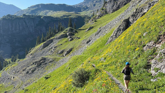
Sneffels Highline
 Photo Credit: Madeleine Balestrier
Distance: 14.3 miles (23 kilometers)
Elevation Gain: 3,986 feet (1215 meters)
Duration: 7-10 hours
Difficulty: Hard
Type: Loop
Location: 37.9412, -107.8124
While Sneffels Highline doesn’t feel as physically demanding as Ballard, it’s a long day of singletrack through wildflowers, waterfalls, and basins that make you feel small. You can grab the trail from the Jud Wiebe or Deep Creek Trail. Sneffels Highline is gorgeous during peak fall foliage.
Wasatch Trail
 Photo Credit: Madeleine Balestrier
Distance: 14.5 miles (23.3 kilometers)
Elevation Gain: 4,324 feet (1,318 meters)
Duration: 8-10 hours
Difficulty: Hard
Type: Loop
Trailhead: 37.9343, -107.8119
Hiking (or Mountain Biking) the Wasatch Trail is an all-day endeavor, but it’s worth it for the wildflowers alone. Aside from a trail lined with an explosion of brilliant colors, the Wasatch guides you through a landscape rife with waterfalls, creeks, and piercing peaks. You can also the trail from Telluride Ski Resort, Bridal Veil, or Bear Creek for easy access!
Local’s Tip: Shuttle a car to Bridal Veil Falls to shorten your hike and bypass having to walk the road or the River Trail back to town. Your feet will be stoked.
Wilson Peak via Rock of Ages Trail
Distance: 9.1 miles (14.5 kilometers)
Elevation Gain: 3,658 feet (1,115 meters)
Duration: 5-8 hours
Difficulty: Hard
Type: Out & Back
Trailhead: 37.883410, -108.018293
Wilson Peak is widely known because it’s on the Coors beer can and a part of the family of 14ers that loom southwest of Telluride. The other two are Mt. Wilson and El Diente. At 14,023 feet, Wilson Peak is a humbling hike with rockfall, route finding, and a false summit. Only do this hike if you’re prepared and confident, or hire a guide!
Shop at Jagged Edge Mountain Gear, the only locally owned mountain gear store in Telluride, Colorado, and check out the brand's locally sewn and USA-made products online or in-store.